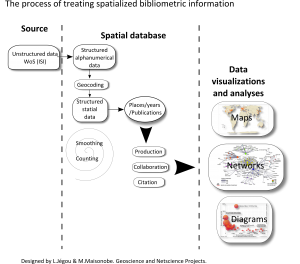
To localize scientific activity, we achieved an almost complete geocoding (98%), for selected years (1999-2014), of the institutional affiliations indexed in 19 millions publications retrieved from the Web of Science Core Collection.
We then grouped localities in what we call “scientific” urban areas. The aim is to simplify and standardize the initial information in order to analyze and visualize it globally (to better understand the method, see the pattern below adapted from Jégou, 2014).

